The Superstition Wilderness has more than 170 miles of trails, so this is a real wilderness range, not a quick roadside stop. Which part of that range works for you comes down to your heat tolerance, water plan, and whether you want a developed basecamp or a more self-supported overnight setup. For most van travelers, the best trip starts with a simple call: camp close, hike early, and pick a trailhead that matches the day you can actually support.
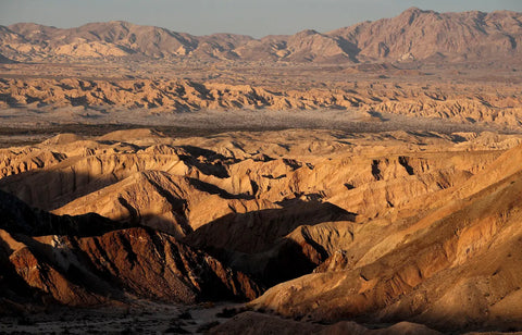
The featured photo shows Superstition Mountain rising above saguaro desert at the edge of town, the view most visitors see on the drive in. (Photo: Waqcku, public domain)
Why the Superstition Mountains deserve a planned approach

The photo above shows the rough rock and saguaro-covered slopes along the Hieroglyphic Trail. Terrain like this is typical of the wilderness. (Photo: ksblack99, public domain)
According to the Tonto National Forest land management plan, the Superstition Wilderness Area spans 160,115 acres across the Globe, Mesa, and Tonto Basin Ranger Districts. That size is the first clue that you are not dealing with one neat park loop or a single scenic turnout. You are stepping into a broad desert backcountry zone.
The same plan singles out Weavers Needle, a weathered volcanic plug that rises to 4,553 feet. That helps explain why route choice matters so much here. A line on a map can look simple. On the ground, it may feel much bigger.
The wilderness has more than 170 miles of trails, and conditions vary from fair to very poor. That gives you choices, but it also makes it easy to pick a route that doesn't fit your pace or water plan.
Visit Mesa frames the range as one of the major outdoor spots east of Mesa and Phoenix. In cooler months, that also means popular trailheads can get busy.
The key call for van travelers is not just which hike to do. It is where to basecamp, and how much support you want when the sun is up and the shade is scarce. If you are still dialing in your setup, pages like Customize your van and Foundation builds show the kind of simple systems that make desert travel easier to live with.
What first-time visitors usually underestimate
Most first-timers underestimate how rough terrain, mixed trail quality, and full sun stack on top of each other. Mileage alone does not tell the whole story here. A trail that looks modest on paper can feel serious by late morning.
Still, the Forest Service describes conditions across the wilderness as highly variable. Marked does not always mean easy to follow.
Maricopa County emergency guidance recommends outdoor activity in the early morning or late evening during extreme heat. That advice matters a lot around the Superstitions, where a sunrise hike can turn into a heat problem by late morning.
Another thing people blur together is land status. State Park land, National Forest land, wilderness rules, and Arizona State Trust Land are not all the same, and each can come with different access or camping expectations. A van with good airflow, bug screens, and enough water helps a lot here, because it turns a rushed dawn outing into a basecamp day you can actually enjoy. If you want ideas for that kind of setup, our van build blog is a good place to start.
Best Superstition Mountains trailheads and what each one leads to
The Forest Service trailhead guide is the most useful official planning tool for this range because it connects each access point to the trails it serves. That sounds basic, but it matters in a place this spread out. Picking the right entry point can save you from a poor match between your goal and your day.
Peralta Trailhead is reached from US 60 via Peralta Road. Officially, it accesses Peralta Trail 102, Dutchman's Trail 104, and Bluff Spring Trail 235. That one detail makes it more flexible than many first-time visitors expect.
Trailhead logistics matter here too. If you leave a van at the trailhead, lock it and keep valuables out of sight.
Visit Mesa's overview highlights Peralta Canyon, Hieroglyphic Canyon, and Siphon Draw and Flatiron as some of the best-known hikes. For a first visit, that gives you a smart shortlist. Match the trailhead to the day you want: iconic scenery, a shorter front-range walk, or a deeper wilderness push.
For van travelers, easy road access and nearby developed camping usually make the first trip better. You can hike at dawn, get back to shade by midday, and still have energy left for camp. If you travel as a pair, layouts like the DUO XL or the vans for couples collection fit that rhythm well.
Peralta Trailhead for classic scenery

The photo above shows Weavers Needle from the Peralta Trail, the classic view many hikers come for. (Photo: Deborah Lee Soltesz, CC0)
Peralta Trailhead is one of the best gateways for classic Superstition scenery because it links to Peralta Trail 102, Dutchman's Trail 104, and Bluff Spring Trail 235. You are not locked into one narrow plan.
Visit Mesa's Lost Dutchman trails guide specifically recommends Peralta Trail for the legend-and-landscape feel many visitors want. It gives you the mood people picture when they think of the Superstitions. You get strong scenery without jumping straight into the roughest options.
Because Peralta connects to multiple trail choices, it works well if you need to shorten or extend the day based on heat, fitness, or start time. That makes it a good first-day call. If the morning already feels warm at the trailhead, you still have room to make a smart choice.
Starting before sunrise is especially useful here because exposed miles feel much longer once the sun is high. Plan the turnaround before you start, not when you are already hot.
Front-range access near Lost Dutchman and Siphon Draw
Lost Dutchman State Park sits at the foot of the range near Apache Junction. For hikers who want a front-door basecamp, it is hard to beat. You are close to the mountains without having to solve every camping detail from scratch.
Visit Mesa highlights Siphon Draw and Flatiron as one of the area's best-known hikes. That makes this front-range zone attractive for ambitious day hikers. At the same time, Prospector's View Trail and the 2.4-mile Treasure Loop Trail offer lower-commitment options with the same setting and story.
This side of the range is often the easiest first choice because you can pair a developed campground with an early trail start and a fast return to camp. That matters in the desert. Midday shade, a cold drink, and a place to reset can save the whole trip.
If your group includes kids, dogs, or mixed fitness levels, front-range access usually makes for a better day than a deeper wilderness route with no easy bailout. Families often do best with a simple plan and a comfortable van basecamp. Our family vans are built around exactly that kind of use.
The Lost Dutchman legend and how it shapes the visit

The photo above looks out from the Dutchman's Trail toward Palomino Mountain on the left and Weavers Needle on the right, the landmark most often tied to the Lost Dutchman story. (Photo: Deborah Lee Soltesz, CC0)
The Lost Dutchman Mine story is still the best-known legend tied to these mountains. For plenty of casual visitors, it is the hook that gets the Superstitions onto the trip list in the first place. The story gives the range a mood that many desert spots do not have.
Visit Mesa's trail guide leans into that legend as a way to explore the area. That tells you something useful: the story still shapes how modern visitors choose hikes. People want a trail that feels tied to the myth, not just a random workout.
Routes like Prospector's View Trail, Dutchman's Trail, and Peralta Trail all carry some of that classic Superstitions feel. Still, the legend works best as context, not as an excuse to treat the place lightly. Forest Service materials stay clear on this point: the terrain is rugged and trail conditions can be inconsistent.
For van travelers, the myth often adds the most value back at camp. A sunset view, a short interpretive walk, and a slower evening can feel more memorable than forcing a huge mileage day.
If you want a van that supports that slower camp rhythm, our Sprinter conversions and Transit conversions show two strong paths for self-supported desert travel. Shade, airflow, and water matter here more than flashy extras.
Best hikes if you want the legend without a full wilderness push
Prospector's View Trail is one of the easiest ways to connect with the Lost Dutchman story on a shorter outing. Visit Mesa recommends it for exactly that reason. You get the theme of the place without a huge commitment.
Treasure Loop Trail is another easy pick. Visit Mesa calls it the best choice for beginners: a 2.4-mile loop with big scenery and forgiving terrain. Dutchman's Trail carries the legend's name, but it is the long, remote option, 15.6 miles with about 2,430 feet of gain, so save it for a cool day and a full water plan.
Peralta Trail adds stronger scenery to that same legendary frame. That makes it one of the better choices if you want both a memorable hike and the classic Superstitions atmosphere. In practice, this mix of shorter and longer options helps you choose based on season and heat tolerance, not just the most famous name on the map.
The best legend-focused day often leaves room for camp photos, a slow dinner, and a little time outside after sunset. That is usually more satisfying than treating the day like a summit checklist. If you are planning your own setup, our process gives a good look at how people build for that style of travel.
Desert heat safety in the Superstition Mountains

The photo above shows a dry wash on the Hieroglyphic Trail in December, with bare rock and almost no shade. In warmer months, terrain like this heats up fast. (Photo: ksblack99, public domain)
Maricopa County's heat guidance recommends outdoor activity in the early morning or late evening during extreme heat. On exposed Superstition trails, that is not just nice advice. It is trip planning.
The same local guidance recommends about 1 quart of water per hour in the heat. That gives you a simple benchmark before you leave camp. If your water plan falls short, the route is already asking too much.
Hikers are also advised to take frequent shade breaks and stay off closed trails during extreme heat advisories. Visit Mesa adds the usual desert basics: bring plenty of water, use sun protection, and stay on established trails. Those points matter even more here because the Forest Service says trail conditions can be poor, which can slow you down and keep you in the sun longer.
For van-based trips, the safest pattern is usually simple: camp close, wake early, hike at first light, and be back to shade and airflow before the hottest part of the day. A van with roof ventilation, window coverings, and enough water storage can turn a marginal desert trip into a safe one. If you are building toward that, our DIY blog covers useful planning topics.
How to decide if a hike is too ambitious for the day
Start with water. If you do not have roughly 1 quart per person per hour in the heat, local guidance suggests the day is under-supported from the start. That is a strong sign to shorten the route.
Next, look at timing and exposure. If the route needs a late start, long exposed climbing, or uncertain trail-finding, the Forest Service warning about variable trail conditions should push you toward a shorter option. Slower travel means more sun, and more sun means less margin.
Maricopa County guidance says to stop activity if heat illness warning signs appear and to call 911 in an emergency. That is worth saying plainly because desert hikers sometimes normalize overheating for too long. The better move on a first visit is usually a shorter sunrise hike, not a bucket-list route started too late.
Families and travelers with dogs should be even more conservative. Desert rock and radiant heat can make a moderate trail feel severe by mid-morning.
Where to camp: Lost Dutchman State Park vs Tonto land vs nearby State Trust land
For most first-time visitors, Lost Dutchman State Park is the most straightforward overnight choice. The official park page covers camping types, reservations, fees, amenities, and trail access in one place. That kind of clarity is hard to beat when you are arriving late or trying to line up a dawn start.
It is also the easiest call if you want certainty. You get a legal overnight stay close to the mountains near Apache Junction, and you do not have to stitch together rules from several agencies. That alone makes the park the best basecamp for a lot of van travelers.
Still, the land picture around the range is not one-size-fits-all. Visit Mesa notes that overnight camping norms, recreation fees, and closure checks vary by location. Arizona State Trust Land is separate from Tonto National Forest, and the Arizona State Land Department FAQs say a recreational permit may be required for uses such as hiking, horseback riding, photography, sightseeing, and bird watching.
That same State Trust Land permit limits overnight camping to no more than 14 cumulative days per year. Entering State Trust Land without a valid permit can lead to trespass consequences, so it pays to verify land status before assuming a pullout or side road is fair game. For most readers, the practical choice is simple: use Lost Dutchman for convenience, or research National Forest and adjacent land status carefully if you want a quieter self-supported setup. If you want help building a van that fits that style, contact us.
When Lost Dutchman State Park is the better basecamp
Lost Dutchman State Park is ideal for first-timers who want reservations, amenities, and predictable access. You do not need to piece together a legal overnight plan across multiple agencies.
Because the park sits at the foot of the Superstitions, it works well for dawn starts on nearby trails and easy returns during the hottest part of the day. That is a very real advantage in hotter months.
This developed campground option is especially useful for families, road-trippers on a schedule, and anyone who wants the simplest version of a desert basecamp. A built van with a comfortable bed, bug control, and a simple outdoor setup can make a state-park stay feel much bigger than tent camping in the same heat.
What to know about Tonto and nearby permit boundaries
Plans are changing on the road to Peralta Trailhead. Pinal County began fencing Peralta Road through State Trust Land in February 2026, closed the informal Wave Cave/Carney Springs parking area on March 2, 2026, and plans to pave the road in 2028 if federal grant funding comes through. Local reporting also describes ditches dug along the road and "no camping" signs at former pullouts, so do not count on roadside camping there.
The Tonto planning document gives the broad management picture for recreation across the area, but you still need to tell National Forest land from nearby State Trust land on the ground. That is where many people slip up. Looking at maps before dark is easier than fixing the mistake later.
Visit Mesa's Lost Dutchman guide specifically notes that Arizona State Trust Land permits may be required in some access situations, depending on where you recreate or park. The Arizona State Land Department confirms that the recreational permit covers hiking, horseback riding, photography, sightseeing, and bird watching. So even a simple stop can involve rules that differ from the next road over.
That permit also allows overnight camping only up to 14 cumulative days per year. For longer desert road trips, that limit matters. For van travelers, permit-boundary confusion is one of the easiest mistakes to avoid by checking maps early and choosing a clearly legal overnight spot.
FAQ
What is the best first hike in the Superstition Mountains?
For many first-time visitors, Peralta Trail is a strong pick because the Forest Service trailhead guide shows that Peralta Trailhead accesses Peralta Trail 102, Dutchman's Trail 104, and Bluff Spring Trail 235. That gives you options if heat, timing, or energy shifts during the day. If you want a simpler front-range outing, Prospector's View, Hieroglyphic Canyon, and Siphon Draw and Flatiron are also popular places to start.
How much water should I bring for Superstition Mountains hiking?
Maricopa County emergency guidance recommends about 1 quart of water per hour in the heat. In the Superstitions, that is a useful minimum because exposed trails and poor route conditions can slow you down. If your water plan does not hit that mark, it is smart to shorten the hike or save it for a cooler day.
Can you camp anywhere around the Lost Dutchman area?
No. Lost Dutchman State Park has its own camping system with reservations, fees, and amenities, while nearby Arizona State Trust Land may require a recreational permit for activities that include hiking and sightseeing. The State Land Department also says overnight camping under that permit is limited to 14 cumulative days per year, so you should check land status before assuming a roadside spot is open to overnight use.
Is the Lost Dutchman legend tied to real trails?
Yes. Visit Mesa's Lost Dutchman trails guide connects the legend to present-day hikes including Prospector's View Trail, Dutchman's Trail, and Peralta Trail. The story is part of the appeal, but it should stay in the background of your planning. The terrain is still rugged, and the Forest Service is clear that trail conditions can vary a lot.
How big is the Superstition Wilderness?
The Superstition Wilderness Area spans 160,115 acres in Tonto National Forest. It also has more than 170 miles of trails. That scale is a big reason trailhead choice and route planning matter so much on a first visit.
About the author

Electra Chronis
Head of Marketing
Electra leads marketing at The Vansmith. She writes across van life, camping and travel, from planning a trip to choosing and building the van that gets you there.
Read more about Electra